
Sanborn Fire Insurance Map, Avon Park, November 1920
The earliest detailed map of Avon Park known to survive, and it is free, public domain, and readable online. Four sheets, drawn for fire insurance underwriters, showing every building in the town with its footprint, construction material, number of stories and use.
| Title on the sheets | Avon Park, DeSoto County, Florida, November 1920 |
| Title in the Library of Congress catalogue | “Sanborn Fire Insurance Map from Avon Park, Highlands County, Florida” |
| Sheets | 4 |
| Publisher | Sanborn Map Company |
| Held at | Library of Congress, item sanborn01234_001 |
| Population given on the map | 1,200 |
Highlands County did not exist yet, which is why the sheets themselves say DeSoto County; the Library of Congress catalogues the item under the modern county, Highlands, which is why citations to it appear in two forms.[sanborn-1920]
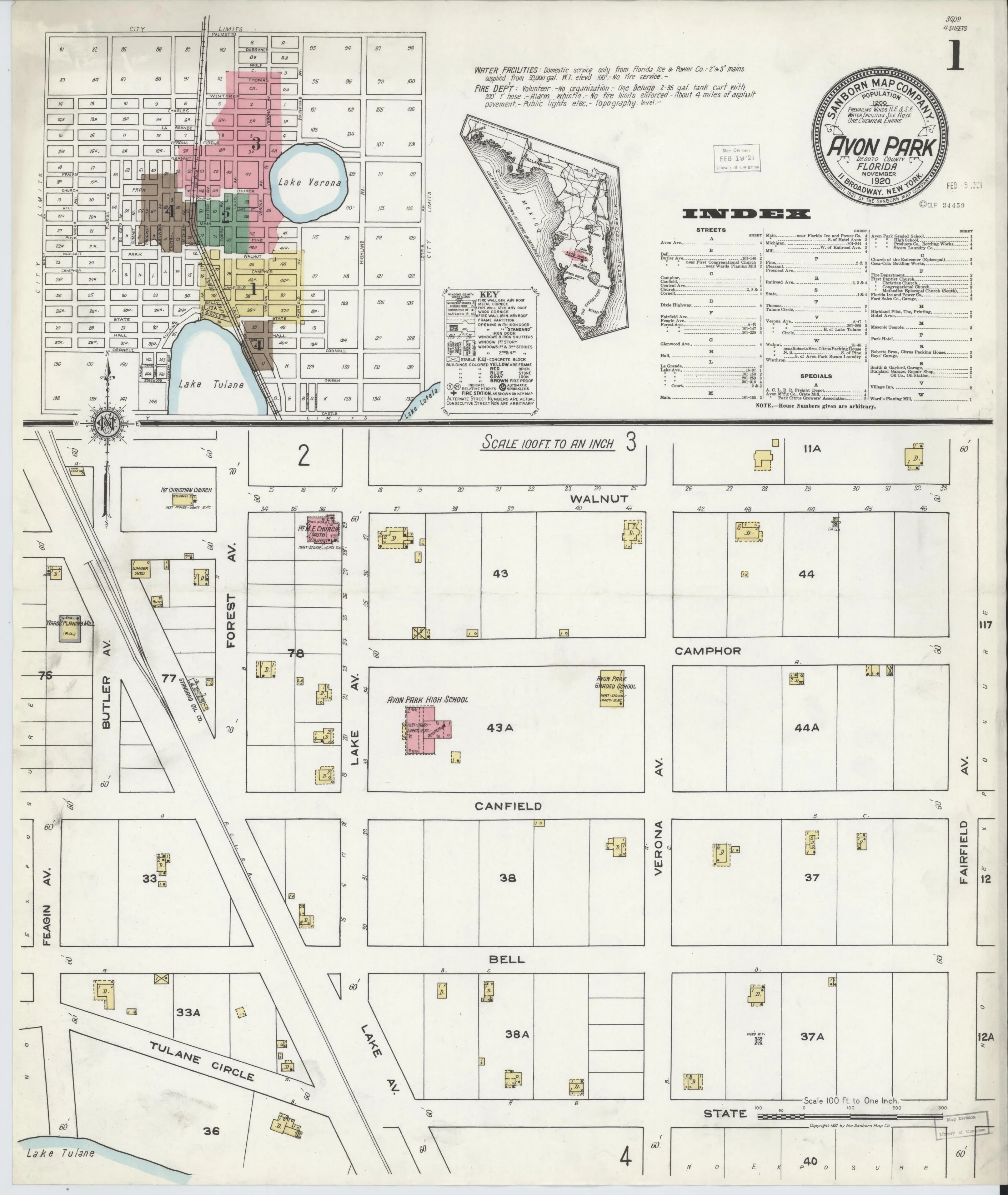
Sheet 1, the index sheet: the key map of the whole town with every block numbered. Sanborn Map Company, via Library of Congress, Geography and Map Division. Public domain.[sanborn-1920]
What is on each sheet
Sheet 1 is the index. It carries a small key map of the whole town, color-coded to the four sheets, with every block numbered — at least 1 to 156, each split by a mid-block alley into a base block and an “A” half-block. It also carries an alphabetical index of streets and an index of named buildings. The lower half is a detail sheet of the south-central residential blocks, including the Avon Park Graded School and High School and the First Christian and Methodist Episcopal churches on Forest Avenue.
Sheet 2 is the Main Street commercial core, at the crossing with the Atlantic Coast Line’s diagonal right of way: the Park Hotel, Smith & Gaylord Garage, the Ford Sales Company garage, the Avon Park Citrus Growers’ and Roberts Brothers’ packing houses backing onto the railroad, the First Baptist Church, a bakery, the printing office of the Highlands Pilot, and a building under construction labeled “to be Motion Picture Theatre.”
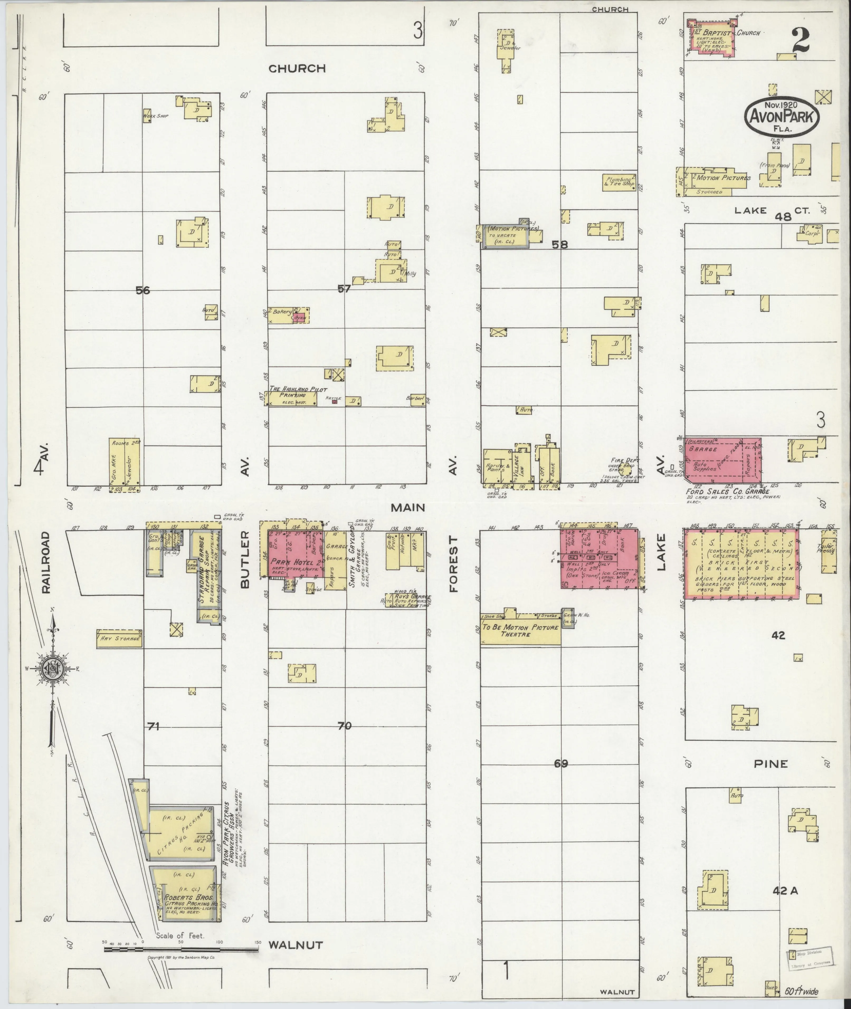
Sheet 2, the Main Street commercial core at the Atlantic Coast Line crossing. Sanborn Map Company, via Library of Congress, Geography and Map Division. Public domain.[sanborn-1920]
Sheet 3 covers the blocks around Lake Verona: the Hotel Avon, the Masonic Temple, the Episcopal Church of the Redeemer, the First Congregational Church, and residential streets — Verona Avenue and Circle, La Grande, Charles, Winthrop, Thomas.
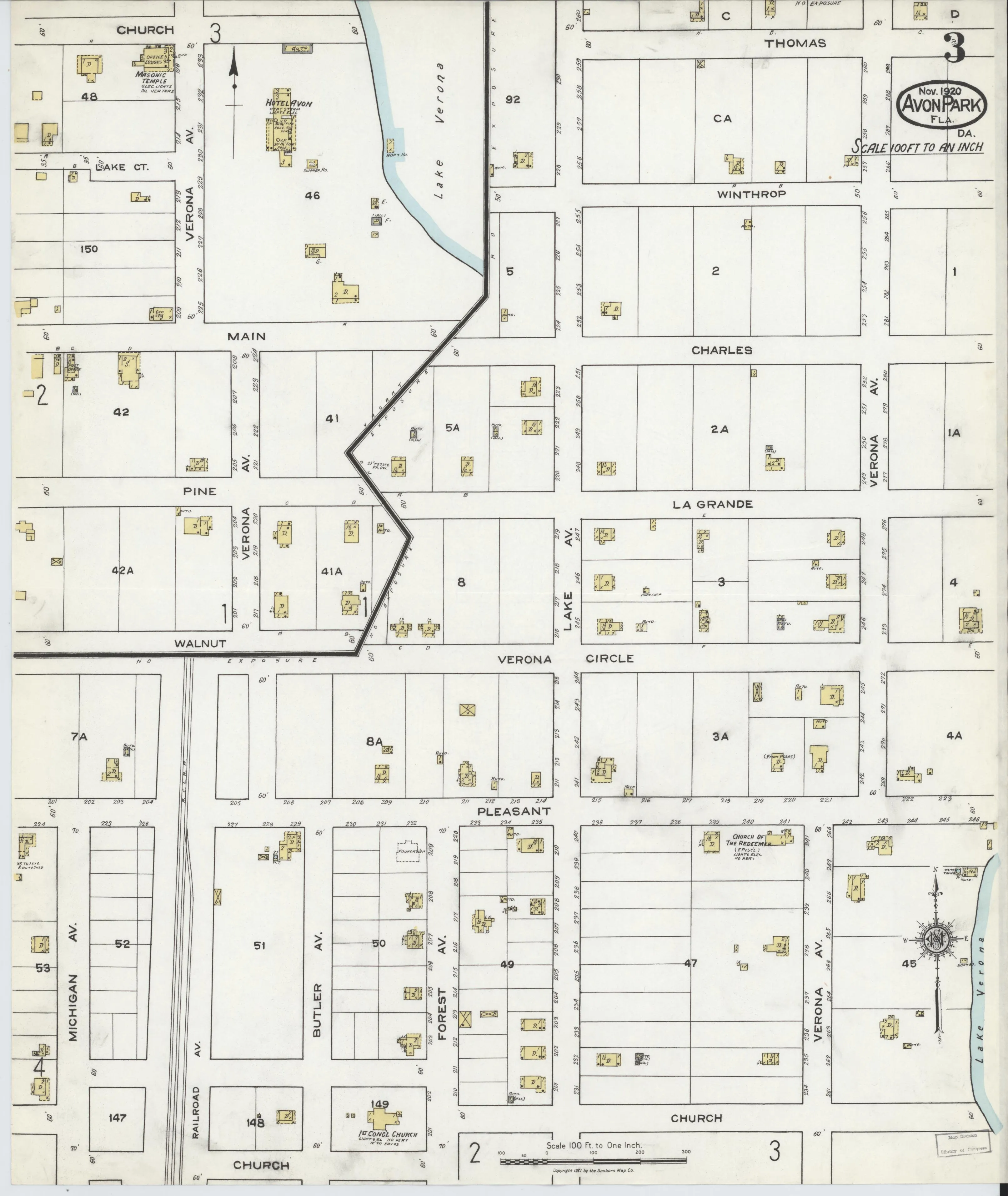
Sheet 3, the blocks around Lake Verona. Sanborn Map Company, via Library of Congress, Geography and Map Division. Public domain.[sanborn-1920]
Sheet 4 covers the southwestern residential blocks and the industrial district: the Florida Ice and Power Company plant and the Avon Park Steam Laundry on Railroad Avenue; the Atlantic Coast Line freight and passenger depot and section house on Michigan Avenue at Church Street; and, a mile and a quarter south of the post office, the Flint Lumber Company’s steam saw mill and planing mill with loading platforms, tram railway, log run, slab pile and refuse burner, alongside the Mutual Crate Company and the Avon Manufacturing Company crate mill.
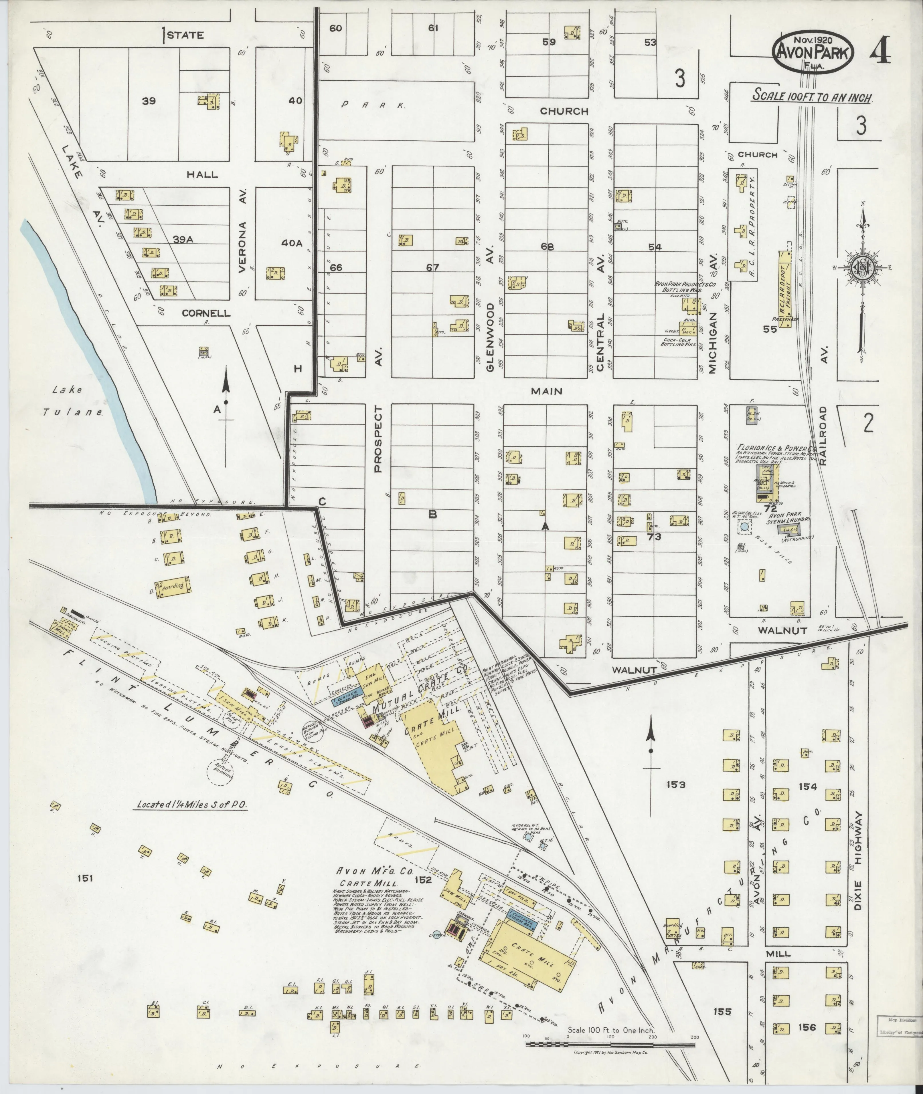
Sheet 4, the southwestern blocks, the depot, and the Flint Lumber Company mill. Sanborn Map Company, via Library of Congress, Geography and Map Division. Public domain.[sanborn-1920]
Why it matters
Three things this map settles.
It shows Main Street with no mall — an ordinary street lined directly by building fronts — which places the Mile Long Mall’s construction after November 1920 and corroborates the National Register’s 1920 to 1927 dating.
It gives the street names in use in 1920, twenty-eight of them, none numbered.
And it shows the town’s industry: a lumber mill and two crate mills serving the citrus trade, with packing houses on the railroad in the middle of town.
The Library of Congress serves the sheet images publicly and they can be viewed in an ordinary browser at the item page.[sanborn-1920]
The later editions are not digitized
Sanborn also mapped Avon Park in February 1926 and reissued a corrected version through May 1939, six sheets each. The Library of Congress catalogues both, and its own records confirm neither has been digitized, so no images exist online.[loc-sanborn-later] Those two editions would show the town at the height of the land boom and immediately after the bust.
| Edition | Library of Congress item | Sheets | Digitized |
|---|---|---|---|
| November 1920 | sanborn01234_001 |
4 | yes |
| February 1926 | sanborn01234_002 |
6 | no — catalogue record only, no image files |
| February 1926 corrected to May 1939 | sanborn01234_003 |
6 | no — catalogue record only, no image files |
The University of Florida does not have them either. UF’s Insurance maps of Avon Park, Florida (UF00074150) is four sheets, so it is the same November 1920 edition, not a second copy of anything later.[ufdc-sanborn]
The remaining routes to the 1926 and 1939 sheets are ProQuest’s Digital Sanborn Maps, which many Florida public libraries give cardholders free, and the Library of Congress Geography and Map Division’s reproduction service.
References
- sanborn-1920 — Sanborn Map Company, via the Library of Congress. Sanborn Fire Insurance Map, Avon Park, DeSoto County, Florida, November 1920 (4 sheets). 1 November 1920. https://www.loc.gov/item/sanborn01234_001/
- loc-sanborn-later — Library of Congress. Catalogue records for the February 1926 and February 1926-May 1939 Avon Park Sanborn editions. 31 August 2026. https://www.loc.gov/collections/sanborn-maps/
- ufdc-sanborn — Sanborn Map Company, via the University of Florida George A. Smathers Libraries. Insurance maps of Avon Park, Florida (UF00074150), University of Florida Digital Collections. 31 August 2026. https://ufdc.ufl.edu/UF00074150/00001
Related
Where this comes from
- Evidence
- single-source — One source. Treat as reported, not established.
- Review
- unverified — Drafted from sources but not yet checked by a volunteer.
- Rights
- society
Sources
- Sanborn Map Company, via the Library of Congress, Sanborn Fire Insurance Map, Avon Park, DeSoto County, Florida, November 1920 (4 sheets) (1920)
- Library of Congress, Catalogue records for the February 1926 and February 1926-May 1939 Avon Park Sanborn editions (2026)
- Sanborn Map Company, via the University of Florida George A. Smathers Libraries, Insurance maps of Avon Park, Florida (UF00074150), University of Florida Digital Collections (2026)
Something here wrong, or incomplete? The Society would rather know. Tell a volunteer.
Have a question about this record?