
Crosby’s Four Parks and the Forty-Acre-Block Misconception
Inquiries regarding whether any of Oliver M. Crosby’s “forty-acre-block parks” survive in Avon Park are based on a conflation of two distinct historical land divisions: the original town plat’s civic parks and the surrounding agricultural tracts.
The Misconception Disentangled
The term “forty-acre-block parks” does not exist in the historical record of Avon Park’s urban planning. Instead, the historical record demonstrates that Crosby’s settlement plan involved two separate concepts:
- The Four Parks (Civic Space): In his 1886 and 1889 plans for the settlement (originally named Lake Forest, later Avon Park), Crosby designed a town layout featuring “four parks and residential lots around the lakes.”[nrhp-avon-park-district] These parks were intentionally incorporated into the grid street patterns to attract settlers, functioning as public greenspaces rather than massive agricultural blocks.
- Forty-Acre Blocks (Agricultural Space): The phrase “forty acres” refers to the historical Public Land Survey System (quarter-quarter sections). Outlying areas beyond the town’s central hub were reserved for citrus and pineapple production, often divided and sold in forty-acre agricultural increments.
Therefore, Crosby did not design forty-acre parks; he designed four civic parks within the town, surrounded by forty-acre agricultural blocks.
Surviving Greenspaces and the Original Plat
While the exact boundaries of the original “four parks” have evolved as the city expanded, the legacy of Crosby’s vision for a town integrated with greenspaces survives on the ground today in two primary forms:
The Mile Long Mall (Main Street) Crosby and his associates meticulously planned the town with two 60-foot-wide boulevards bisecting the center of the townsite.[florida-memory-rc17233] This broad streetscape evolved into the “Main Street Mall,” a central planted median that serves the role of a traditional town square or park, preserving the open greenspace intended by the founders.[florida-memory-c670452]
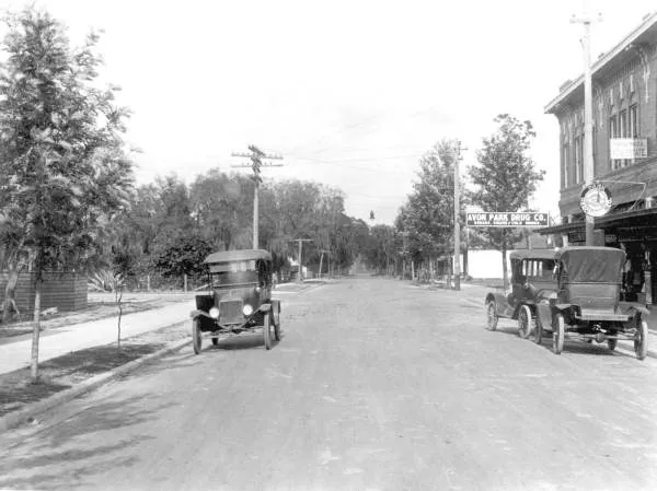 Sand asphalt pavement laid on Main Street in 1916, showing the broad boulevards planned by Crosby. (State Archives of Florida, Florida Memory) [florida-memory-rc17233]
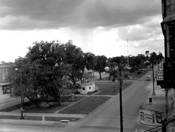 The planted medians and parks integrated into the street layout of early Avon Park. (State Archives of Florida, Florida Memory) [florida-memory-c670452]
Lakefront Parks Crosby’s original design emphasized parks and residential lots arranged around the local lakes. Today, public access and recreational spaces along the shores of Lake Verona, Lake Byrd, and Lake Tulane fulfill this purpose. Notably, Donaldson Park (109 E Main Street) operates as a primary public greenspace on the historic site of the Verona Hotel, aligning with the original town’s lakeside orientation.
References
- nrhp-avon-park-district — Stephen A. Olausen and Barbara E. Mattick. National Register of Historic Places Registration Form: Avon Park Historic District (ref. 90000486). 22 March 1990. bundle/references/nrhp-avon-park-historic-district-1990.md
- florida-memory-rc17233 — Unknown. Looking down Main Street - Avon Park, Florida. 1916. https://www.floridamemory.com/items/show/17233
- florida-memory-c670452 — Unknown. Planted median - Avon Park, Florida. 1916. https://www.floridamemory.com/items/show/330554
Related
Where this comes from
- Evidence
- corroborated — More than one independent source agrees.
- Review
- unverified — Drafted from sources but not yet checked by a volunteer.
- Rights
- society
Sources
- Stephen A. Olausen and Barbara E. Mattick, National Register of Historic Places Registration Form: Avon Park Historic District (ref. 90000486) (bundle/references/nrhp-avon-park-historic-district-1990.md) (1990) · official
- Unknown, Looking down Main Street - Avon Park, Florida (1916) · archival
- Unknown, Planted median - Avon Park, Florida (1916) · archival
Something here wrong, or incomplete? The Society would rather know. Tell a volunteer.
Have a question about this record?