
Eighteenth-century colonial cartography and the absence of Highlands County place-names
No eighteenth-century British or Spanish colonial map placed a town, mission, military post, Indigenous village, road, or named geographic feature within the territory that became Highlands County.[cumming-1998] Modern Highlands County spans approximately 27°10’ N to 27°40’ N latitude and 80°50’ W to 81°35’ W longitude on the southern Lake Wales Ridge and the upper Kissimmee River basin. In eighteenth-century European surveys, this entire expanse remained an unvisited cartographic blank.
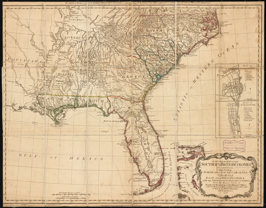
Bernard Romans, A General Map of the Southern British Colonies in America, 1776. Norman B. Leventhal Map & Education Center at the Boston Public Library. Public domain.[romans-1776-map]
British surveys of the southern district
During the British period of East Florida (1763–1783), the British Crown dispatched official surveyors to map the provinces and define territorial boundaries with Indigenous nations. None of these expeditions entered the southern Lake Wales Ridge:
- William Gerard De Brahm (1765–1771): As Surveyor General of the Southern District of North America, De Brahm conducted an extensive hydrographic survey of the Atlantic coastline, the Florida Keys, and the Gulf coast up to Tampa Bay, alongside an inland ascent of the St. Johns River south to its headwaters in 1768.[cumming-1998] In his 1769 map The Ancient Tegesta, Now Promontory of East Florida, De Brahm delineated coastal rivers, capes, and barrier islands with astronomical precision but explicitly left the south-central peninsular interior vacant.[de-brahm-1769-map] The place-name “Lake Sandwich,” sometimes mistakenly associated with the interior lakes, was De Brahm’s designation for Biscayne Bay on the southeastern Atlantic coast, named in honor of John Montagu, 4th Earl of Sandwich.[cumming-1998]
- John Stuart and Joseph Purcell (1775): Commissioned by John Stuart, British Superintendent of Indian Affairs for the Southern District, surveyor Joseph Purcell compiled A Map of the Southern Indian District of North America to delineate the 1763 Proclamation line, treaty boundaries, Indian trade paths, and tribal settlement clusters.[stuart-purcell-1775-map] Purcell documented Creek, Cherokee, and Choctaw towns across the Southeast and traced the northern military route between St. Augustine and Pensacola. Peninsular Florida south of Tampa Bay and Lake George was left beyond the boundary of surveyed trade paths and carried no interior place-names or topography.[stuart-purcell-1775-map]
- Bernard Romans (1775–1776): As a civil engineer and marine surveyor, Romans mapped the Florida coastlines and navigational channels, publishing his findings in marine charts and his 1776 General Map of the Southern British Colonies in America.[romans-1776-map] While Romans provided detailed nautical soundings and labeled coastal landmarks from Tampa Bay to Charlotte Harbor, his map left the interior south of 28° N entirely blank, containing neither lakes, watercourses, nor settlements.[romans-1776-map]
- Thomas Jefferys (1775): Geographer to King George III, Thomas Jefferys published The Peninsula and Gulf of Florida in The American Atlas.[jefferys-1775-map] Jefferys showed a heavily articulated coastline, labeling “Spiritu Santo Lagoon” (Lake Okeechobee) and “Bay of Spiritu Santo” (Tampa Bay). Between Charlotte Harbor and the Atlantic, the interior expanse of the Lake Wales Ridge contained no named rivers, hills, or communities.[jefferys-1775-map]
Spanish colonial mapping
Eighteenth-century Spanish cartography of Florida focused almost exclusively on military defense of the maritime approaches, the presidio of St. Augustine, the garrison of San Marcos de Apalache, and the northern mission trail:
- Antonio de Arredondo (1742): Chief engineer Antonio de Arredondo drafted Descripcion Geografica de la Parte que los Españoles Poseen Actualmente en el Continente de la Florida to assert Spanish imperial claims against British incursions from Georgia.[arredondo-1742] Arredondo meticulously plotted the Atlantic coastal forts, the barrier islands, and the overland route across the Florida panhandle, but drew the southern half of the peninsula as an empty outline without interior rivers or towns.[arredondo-1742]
- Juan José Elixio de la Puente (1768): Following the 1763 cession of Florida to Great Britain, Elixio de la Puente produced detailed maps of the properties, churches, and fortifications of St. Augustine and the surrounding region.[de-la-puente-1768] His regional maps depicted the remnants of the Timucua and Guale missions and coastal presidio outposts; the interior south of the upper Kissimmee River was treated as an unmapped wilderness.[de-la-puente-1768]
Neither the Kissimmee River, Lake Istokpoga, nor any of the sixty natural sand-bottom ridge lakes of modern Highlands County appeared on European maps until nineteenth-century federal military surveys during the Seminole Wars.[cumming-1998]
References
- romans-1776-map — Bernard Romans. A General Map of the Southern British Colonies in America. 1776. https://collections.leventhalmap.org/search/commonwealth:9s161c45m
- de-brahm-1769-map — William Gerard De Brahm. The Ancient Tegesta, Now Promontory of East Florida. 1769. https://collections.leventhalmap.org/search/commonwealth:7h149x640
- stuart-purcell-1775-map — John Stuart and Joseph Purcell. A Map of the Southern Indian District of North America Compiled under the Direction of John Stuart Esqr. by Joseph Purcell (PRO CO 700/North American Colonies General 12), catalogued in Early Maps of the American South. 1775. https://rla.unc.edu/emas/PRO-CO700.html
- jefferys-1775-map — Thomas Jefferys. The Peninsula and Gulf of Florida, or New Bahama Channel with the Bahama Islands. 1775. https://collections.leventhalmap.org/search/commonwealth:9s161c565
- cumming-1998 — William P. Cumming. The Southeast in Early Maps (Third Edition, revised by Louis De Vorsey Jr.). 1998. https://upress.virginia.edu/title/1543/
- de-la-puente-1768 — Juan José Elixio de la Puente. Plano de la Real Fuerza, Baluartes, y Parroquial de San Agustín con sus Casas… y de las Provincias de la Florida. 1768. https://www.loc.gov/item/2007627402/
- arredondo-1742 — Antonio de Arredondo. Descripcion Geografica de la Parte que los Españoles Poseen Actualmente en el Continente de la Florida. 1742. https://www.loc.gov/item/2004629033/
Where this comes from
- Evidence
- corroborated — More than one independent source agrees.
- Review
- unverified — Drafted from sources but not yet checked by a volunteer.
- Rights
- society
Sources
- Bernard Romans, A General Map of the Southern British Colonies in America (1776) · archival
- William Gerard De Brahm, The Ancient Tegesta, Now Promontory of East Florida (1769) · archival
- John Stuart and Joseph Purcell, A Map of the Southern Indian District of North America Compiled under the Direction of John Stuart Esqr. by Joseph Purcell (PRO CO 700/North American Colonies General 12), catalogued in Early Maps of the American South (1775) · archival
- Thomas Jefferys, The Peninsula and Gulf of Florida, or New Bahama Channel with the Bahama Islands (1775) · archival
- William P. Cumming, The Southeast in Early Maps (Third Edition, revised by Louis De Vorsey Jr.) (1998) · book
- Juan José Elixio de la Puente, Plano de la Real Fuerza, Baluartes, y Parroquial de San Agustín con sus Casas... y de las Provincias de la Florida (1768) · archival
- Antonio de Arredondo, Descripcion Geografica de la Parte que los Españoles Poseen Actualmente en el Continente de la Florida (1742) · archival
Something here wrong, or incomplete? The Society would rather know. Tell a volunteer.
Have a question about this record?