
Earliest cartographic appearance of Lake Istokpoga and the Kissimmee River
Among territorial and Second Seminole War maps directly examined for this subject, an 1837 sheet published at the Headquarters of the Army and lithographed by Philip Haas is the earliest found naming both Lake Istokpoga and the Kissimmee watercourse. The University of South Florida catalogues it as Map, Teatre of Military Operations in Florida during 1835, 36 & 37, 1837, by the United States Army and P. Hans, with identifier U15-9023, reflecting a clerical misreading of Haas’s cursive lithographic signature beneath the neatline.[usf-hans-1837] This finding does not rule out an unexamined manuscript or map outside that corpus using either name earlier.
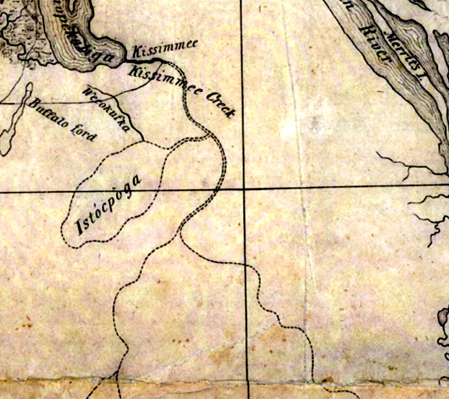
Detail showing Kissimmee Creek and Istòcpoga from United States Army and Philip Haas, Map, Teatre of Military Operations in Florida during 1835, 36 & 37, 1837. University of South Florida Digital Commons, Florida Maps Collection, Image 119. Public domain.[usf-hans-1837]
Territorial cartographic baseline
The 1823 Vignoles and Tanner sheet examined for this question omits both names.[vignoles-1823-map] William Henry Swift’s 1829 map ends at 28°00′ N, north of Lake Istokpoga and the lower Kissimmee basin; it cannot establish a negative for that area.[swift-1829-map]
Philip Haas’s 1837 sheet
According to the engraved labels on the 1837 sheet itself, the watercourse southeast of Lake Tohopekaliga is named “Kissimmee Creek” and the lake is named “Istòcpoga,” with a grave accent on the second syllable.[usf-hans-1837] On the same sheet, Istòcpoga is drawn with a dotted outline, unlike the hachured shorelines at Lake Tohopekaliga and the northern water body; the map itself offers no key or note explaining that difference.[usf-hans-1837]
The sheet also labels “Buffalo ford” and “Wekokufka” beside the creek, giving that map’s own names for places along the regional route.[usf-hans-1837]
Later military mapping
Washington Hood’s Map of the Seat of War in Florida dates from 1838, so it is useful as later comparison but cannot establish an earlier naming than the 1837 Hans sheet.[hood-1838-map]
Related
- Eighteenth-century colonial cartography and the absence of Highlands County place-names
- Indigenous interior accounts and Lake Wales Ridge topography in the survey texts of Bernard Romans and William Gerard De Brahm
- Army reconnaissance limits and the cartographic origin of Kissimmee and Istokpoga in 1836–1837
- Muscogee etymology of Istokpoga
- The 1843 reservation boundary at Lake Istokpoga
- Lake Wales Ridge
- Avon Park Air Force Range
References
- usf-hans-1837 — United States. Army and P. Hans. Map, Teatre of Military Operations in Florida during 1835, 36 & 37, 1837. 1837. https://digitalcommons.usf.edu/fl_maps_collection/119
- vignoles-1823-map — Charles Blacker Vignoles and Henry Schenck Tanner. Map of Florida. 1823. https://www.loc.gov/item/2003627045/
- swift-1829-map — William Henry Swift. Map of Florida: Constructed Principally from Authentic Documents in the Land Office at Tallahassee. 1829. https://www.loc.gov/item/2005625323/
- hood-1838-map — Washington Hood. Map of the Seat of War in Florida. 1838. https://www.loc.gov/item/2018588050/
Where this comes from
- Evidence
- single-source — One source. Treat as reported, not established.
- Review
- unverified — Drafted from sources but not yet checked by a volunteer.
- Rights
- society
Sources
- United States. Army and P. Hans, Map, Teatre of Military Operations in Florida during 1835, 36 & 37, 1837 (1837) · archival
- Charles Blacker Vignoles and Henry Schenck Tanner, Map of Florida (1823) · archival
- William Henry Swift, Map of Florida: Constructed Principally from Authentic Documents in the Land Office at Tallahassee (1829) · archival
- Washington Hood, Map of the Seat of War in Florida (1838) · archival
Something here wrong, or incomplete? The Society would rather know. Tell a volunteer.
Have a question about this record?