
The Photographic and Visual Record of the William R. Reck House
The pioneer two-story residence of civic booster William R. Reck, situated on Block 4 of the original Town of Avon Park plat from circa 1913 until its mid-century relocation and eventual demolition, represents one of the town’s most historically significant lost domestic structures[nrhp-90000486][maxwell-1976]. A comprehensive survey of photographic archives, published local histories, and state collections reveals that no ground-level exterior or interior photograph of the residence is known to survive in public repositories. In place of conventional street-level photography, the physical form, orientation, and landscape setting of the Reck house are preserved through detailed cartographic surveys and federal aerial imagery.
The Archival Photographic Census
The Avon Park Historical Society Depot Museum maintains an extensive negative and print archive documenting late-nineteenth- and early-twentieth-century Avon Park, including photographic series of early Main Street businesses, the 1889 Hotel Verona, the 1926 Hotel Jacaranda, railroad facilities, citrus packing houses, and pioneer residences[maxwell-1976].
When historian Leoma Bradshaw Maxwell compiled The First Hundred Years of Avon Park, Florida (1976) from the collections of the Depot Museum and the Old Settlers Association:
- Maxwell devoted a dedicated account to the mortuary history of Avon Park (p. 96), specifically detailing the 1929 purchase of the “large two-story home of W. R. Reck on East Circle Street” by Dr. Joe Lander, its operation by Jack M. Stephenson, and its 1955 relocation to the corner facing North Verona Avenue[maxwell-1976].
- While Maxwell illustrated adjacent pages with rare vintage views of the Poinsettia Hotel (p. 97) and early winter guests at Hotel Verona (p. 98), no photograph of the Reck residence was reproduced[maxwell-1976].
- Likewise, surveys of the photographic holdings of the State Archives of Florida (Florida Memory), the University of Florida Digital Collections, and the 1989 Avon Park Historic District National Register survey contain no cataloged ground-level photographs of the house in either its original East Circle Street location or its relocated position on North Verona Avenue[nrhp-90000486].
Cartographic Visual Record (Sanborn 1920)
In the absence of street-level photography, the most precise architectural record of the Reck house in its original setting is Sheet 3 of the November 1920 Sanborn Fire Insurance Map[sanborn-1920].
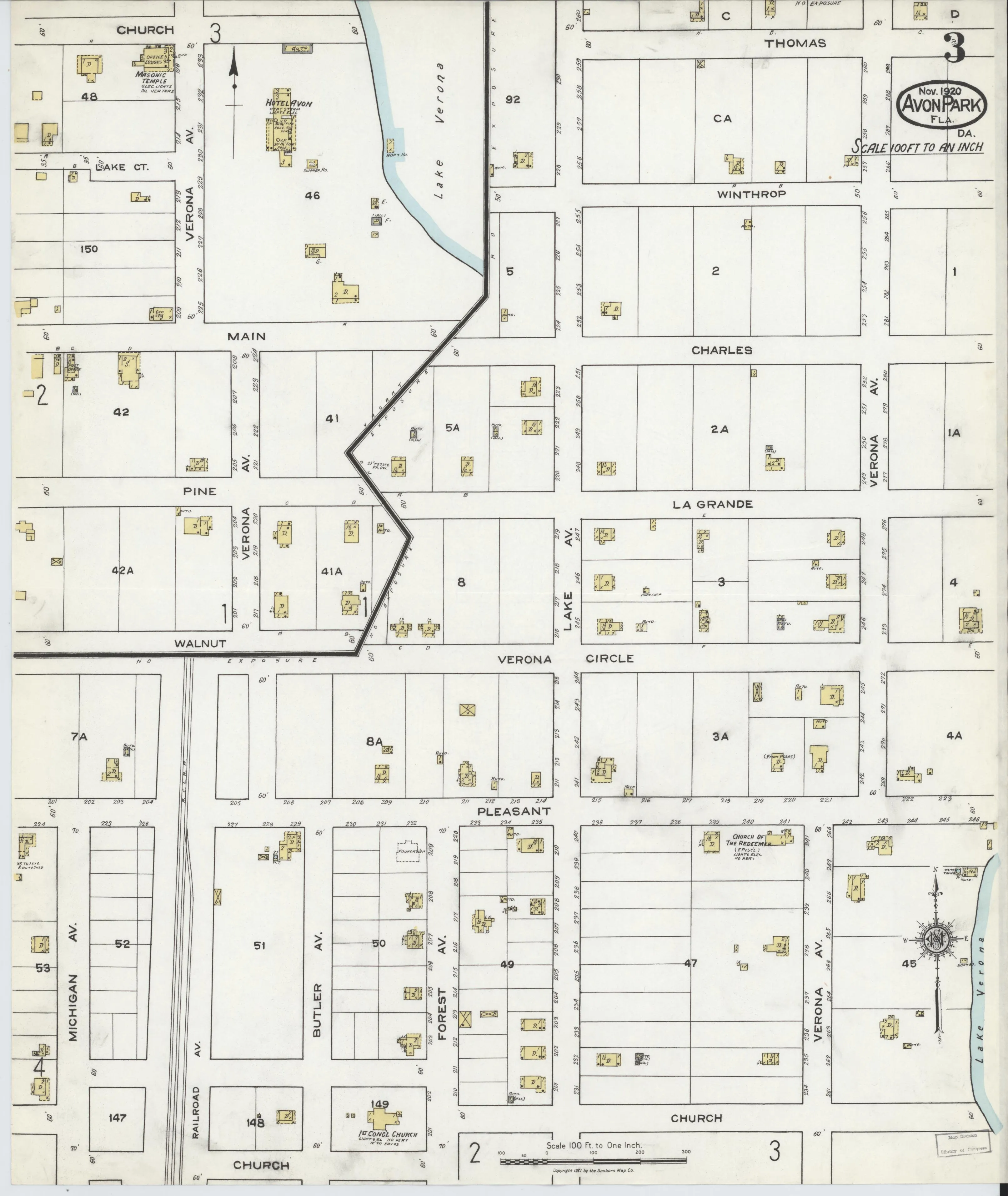
Sheet 3 of the November 1920 Sanborn Fire Insurance Map depicts Block 4, showing the detailed architectural footprint, veranda, and outbuildings of the William R. Reck residence facing Verona Circle. Sanborn Map Company, via Library of Congress, Geography and Map Division. Public domain.[sanborn-1920]
The 1920 Sanborn survey documents specific structural features:
- Massing and Construction: The dwelling is designated “2” (two stories) and “D” (dwelling), constructed of wood-frame framing with a wood-shingle or composition roof[sanborn-1920].
- Veranda and Orientation: The primary facade faces southeast along the curving sweep of Verona Circle (now East Circle Street), fronted by a wide, full-width one-story covered veranda facing the parkway[sanborn-1920].
- Outbuildings: A one-story frame automobile garage and utility shed stood directly northwest of the main house, accessible from North Verona Avenue (street numbers 273 through 276)[sanborn-1920].
- Grounds: The house occupied a commanding position on Lots 3, 4, and 5 of Block 4, directly opposite the residential circle parkway north of Lake Verona[sanborn-1920].
High-Altitude Aerial Surveys (1944 and 1952)
Federal aerial photography provides authentic overhead visual documentation of the house and its surrounding grounds during its quarter-century adaptation as the Stephenson-Nelson Funeral Home:
- 24 November 1944 (Flight 8C, Tile 7): A high-resolution aerial survey frame flown for the United States Department of Agriculture captures the original Town of Avon Park grid[ufdc-aerial-1944-8c-7]. The image shows Block 4 fronting East Circle Street, where the distinctive pitched roofline and shadow of the two-story Reck residence are clearly visible amid mature shade trees and domestic lawn, prior to any commercial paving or relocation[ufdc-aerial-1944-8c-7].
- 9 April 1952 (Flight 2H, Tile 101): Flown shortly after the conclusion of Marion H. and Helen Peyer Nelson’s residential tenure in the second-floor apartment, this USDA survey confirms the continued presence of the pioneer house on its original East Circle Street footprint, three years prior to the 1955 construction of the modern brick-and-masonry mortuary[ufdc-aerial-1952-2h-101].
Together, the 1920 fire insurance plan, mid-century aerial surveys, and modern property appraiser parcel records preserve a complete physical record of the lost residence’s dimensions, scale, and spatial relationship to the town’s historic streetscape[sanborn-1920][ufdc-aerial-1944-8c-7][hcpao-circle-parcel].
References
- sanborn-1920 — Sanborn Map Company, via Library of Congress. Sanborn Fire Insurance Map, Avon Park, DeSoto County, Florida, November 1920 (Sheet 3). 1 November 1920. https://www.loc.gov/item/sanborn01234_001/
- maxwell-1976 — Leoma Bradshaw Maxwell. The First Hundred Years of Avon Park, Florida. 1976. Held at the Avon Park Historical Society Depot Museum, Avon Park, Florida
- ufdc-aerial-1944-8c-7 — University of Florida Map & Imagery Library / U.S. Department of Agriculture. Aerial photographs of Highlands County, Flight 8C (1944), Tile 7. 24 November 1944. https://ufdc.ufl.edu/UF00071754/00008
- ufdc-aerial-1952-2h-101 — University of Florida Map & Imagery Library / U.S. Department of Agriculture. Aerial photographs of Highlands County, Flight 2H (1952), Tile 101. 9 April 1952. https://ufdc.ufl.edu/UF00071754/00010
- hcpao-circle-parcel — Highlands County Property Appraiser. Highlands County Property Appraiser Parcel A-22-33-28-010-0040-0030, 111 E Circle St, Avon Park. 5 September 2026. https://www.hcpao.org/Search/Parcel/28332201000400030A
- nrhp-90000486 — National Park Service / Florida Bureau of Historic Preservation. National Register of Historic Places Registration Form: Avon Park Historic District. 22 March 1990. https://npgallery.nps.gov/NRHP/GetAsset/NRHP/90000486_text
Related
- Finding: The William R. Reck House Relocation and Stephenson Mortuary Redevelopment (1955)
- Finding: The Demolition Dating of the Relocated William R. Reck House and Mortuary Parking Expansions
- Entity: William Reck
- Entity: Stephenson-Nelson Funeral Home
- Entity: Avon Park Historical Society and the Depot Museum
- Report: Notable Historic Houses and Builders of Avon Park
- Reference: Sanborn Fire Insurance Map, Avon Park, November 1920
Where this comes from
- Evidence
- corroborated — More than one independent source agrees.
- Review
- unverified — Drafted from sources but not yet checked by a volunteer.
- Rights
- society
Sources
- Sanborn Map Company, via Library of Congress, Sanborn Fire Insurance Map, Avon Park, DeSoto County, Florida, November 1920 (Sheet 3) (1920) · archival
- Leoma Bradshaw Maxwell, The First Hundred Years of Avon Park, Florida (Held at the Avon Park Historical Society Depot Museum, Avon Park, Florida) (1976) · book
- University of Florida Map & Imagery Library / U.S. Department of Agriculture, Aerial photographs of Highlands County, Flight 8C (1944), Tile 7 (1944) · archival
- University of Florida Map & Imagery Library / U.S. Department of Agriculture, Aerial photographs of Highlands County, Flight 2H (1952), Tile 101 (1952) · archival
- Highlands County Property Appraiser, Highlands County Property Appraiser Parcel A-22-33-28-010-0040-0030, 111 E Circle St, Avon Park (2026) · official
- National Park Service / Florida Bureau of Historic Preservation, National Register of Historic Places Registration Form: Avon Park Historic District (1990) · official
Something here wrong, or incomplete? The Society would rather know. Tell a volunteer.
Have a question about this record?